Kentucky bluegrass, Fescue, Rye and Bent, etc
-
andy10917
- Posts: 29741
- Joined: February 23rd, 2009, 10:48 pm
- Location: NY (Lower Hudson Valley)
- Grass Type: Emblem KBG (Front); Blueberry KBG Monostand (Back)
- Lawn Size: 1 acre-2 acre
- Level: Advanced
Post
by andy10917 » November 19th, 2018, 9:42 am
So, you got caught surprised by a "early first snow"? Was it really "early"?
Attached is a link to CLIMATE.GOV data, which takes information from 1981-2018 and predicts when a location near you will experience a first snow of 0.1" or greater (50% or greater probability). It takes a little zooming to identify the area nearest you with data, but it's interesting.
Maybe you can use this data to ascertain the average time between Average First Frost Date and First Snowfall to assist in predicting when you might get "locked out" of applying the last Urea app, but remember that 0.1" of snow is not the end-of-season, and it's often just a tiny nuisance snow. But, the shorter the span between first frost and first snow, the greater the likelihood that you're in an area in which the window to get the last application will be on the shorter side of the 2-3 week window instead of the longer side - and a real snow may completely block you out of the window (because you just can't apply it after a major snowfall...
Here's a picture of what the data map looks like, and the link to the interactive site is below it:
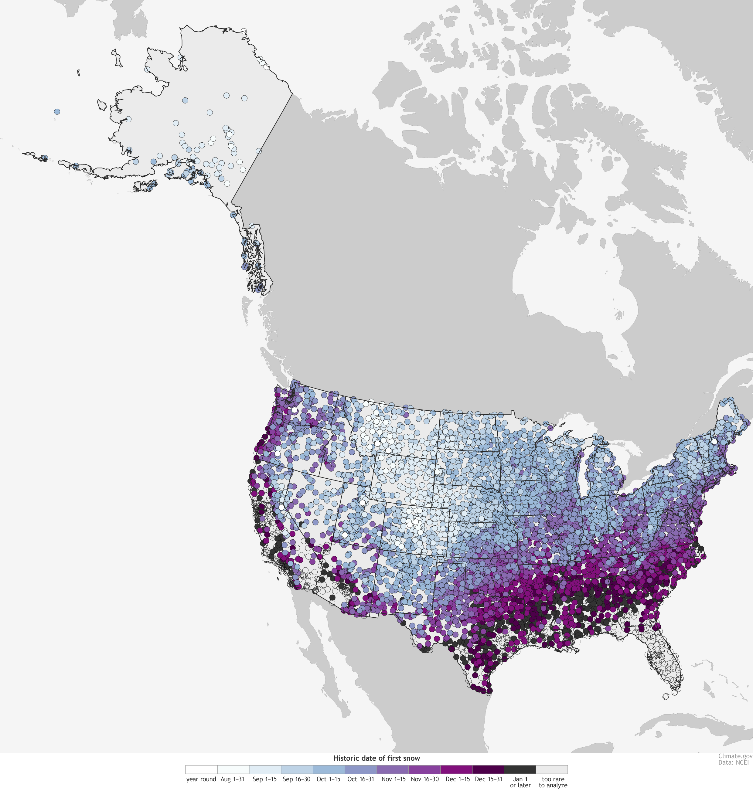 Average First Snow Dates
-
Green
- Posts: 6838
- Joined: September 14th, 2012, 10:53 pm
- Location: CT (Zone 6B)
- Grass Type: KBG, TTTF, TTPR, and FF (various mixtures)
- Lawn Size: 10000-20000
- Level: Experienced
Post
by Green » November 19th, 2018, 1:45 pm
Interesting tool, and thanks for posting, as this is the topic a lot of us are dealing with. I hadn't seen that specific tool. But I had read over and over that in my area, the first significant snow tends to be in December. Whatever significant means in that case. Now, looking at the map, it seems I'm right on the border of the Blue/mid to late Oct. and reddish-purple/early to mid Nov. zones. This means my area typically gets 0.1 inch or more snow sometime between early Oct. and mid Nov. The thing is, it's usually less than an inch. This year it was more than 10x that, and I still have around 80% snow cover today. Finally, my average first snow period may actually start 2 weeks *before* my average first frost date according to the data! This all taken together means I'm heading toward the point of no return. It's a nice additional piece of information I can now use to predict what's likely, and when I should apply my final app (if I get the proper conditions) in this weird year. Thanks, Andy.
-
MorpheusPA
- Posts: 18136
- Joined: March 5th, 2009, 7:32 pm
- Location: Zone 6 (Eastern PA)
- Grass Type: Elite KBG
- Lawn Size: 10000-20000
- Level: Advanced
Post
by MorpheusPA » November 21st, 2018, 10:55 am
Fun, but we might have 0.1" around November first. This was nine inches, which is rare before January and set a record.

Temperatures did rebound, it's completely melted off here, and my urea application got nicely watered in. Just in time for temperatures to plunge to thirteen degrees tomorrow night in yet another example of Global Climate Change Weirdness that we wouldn't normally see until early February.
So, no-longer-so-odd-for-me, the lawn looks like it'll shut down as the top of it singes and turns brown. The deeper layers will stay green, but you won't see them under the dead stuff.
Who is online
Users browsing this forum: No registered users and 19 guests
